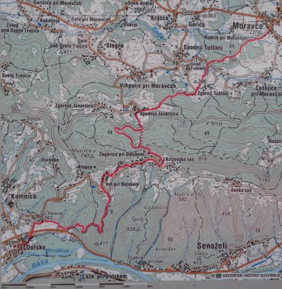

![]() Der Vega-Wanderweg führt von Dolsko, das von Ljubljana gut mit dem
Linienbus zu erreichen ist, über Zagorica, wo sich das Geburtshaus von
Jurij Vega
befindet, nach Moravče, wo J. Vega zur Schule ging. Auf dem oben wiedergegebenen
Kartenausschnitt liegt Dolsko links unten und Moravče rechts oben. Auch Moravče
ist mit Linienbussen von Ljubljana aus zu erreichen.
Der Vega-Wanderweg führt von Dolsko, das von Ljubljana gut mit dem
Linienbus zu erreichen ist, über Zagorica, wo sich das Geburtshaus von
Jurij Vega
befindet, nach Moravče, wo J. Vega zur Schule ging. Auf dem oben wiedergegebenen
Kartenausschnitt liegt Dolsko links unten und Moravče rechts oben. Auch Moravče
ist mit Linienbussen von Ljubljana aus zu erreichen.
Am Vega-Wanderweg liegen die nachstehenden angegebenen Sehenswürdigkeiten zu Jurij Vega:
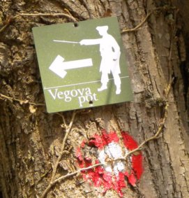
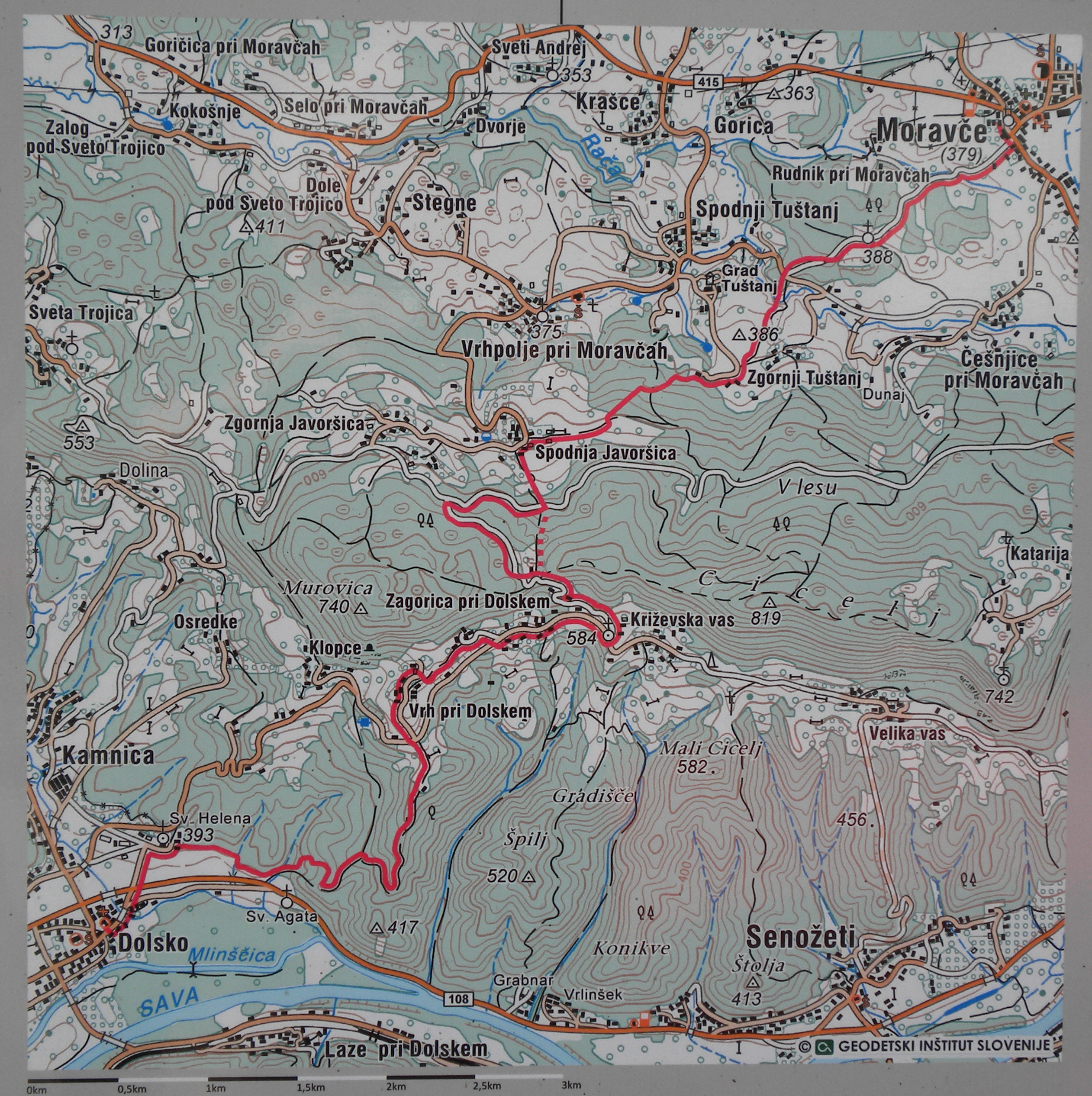
Der Wanderweg ist nur sporadisch markiert - meist nur mit der weißen, rot berandeten Kreisfläche (siehe Bild am Ende dieser Seite). Der Verlauf1)2) des Vega-Wanderwegs (so wie er vom Autor erwandert wurde) kann im Dateiformat GPX durch Anklicken des vorstehenden Verweises heruntergeladen werden. Daneben ist obige Landkarte auch als Fotografie in höherer Auflösung verfügbar.
Die Fotos wurden im März 2012 aufgenommen.
1) Die Daten wurden mit einem GPS-Gerät der Marke GARMIN etrex legend HCx erfasst. Umwege sind in der Datei im Format GPX auskommentiert; dort, wo die erfassten Daten von der Realität (Google Maps) signifikant abweichen, wurden die erfassten Daten ebenfalls auskommentiert und durch manuell erfasste Positionen ergänzt. Letztere sind daran zu erkennen, dass ihnen keine Höhenangabe und auch kein Zeitstempel zugeordnet ist. (Zurück zum Bezug)
2) Das Datenformat GPX ist ein XML-Standard, der auch von Software für GPS-Geräte unterstützt wird. Diese Datei wird als ZIP-Archiv bereitgestellt. (Zurück zum Bezug)
Trail02 auf einer größeren Karte anzeigen |
![]() The Vega Trail starts in Dolsko which is appropriately accessible by bus from
Ljubljana. First it leads to Zagorica, where
Jurij Vega
was born, and to Moravče, where J. Vega went to school. The map shown above unveils
Dolsko at its lower left corner and Moravče at the upper right one. But also
Moravče is connected to Ljubljana by bus.
The Vega Trail starts in Dolsko which is appropriately accessible by bus from
Ljubljana. First it leads to Zagorica, where
Jurij Vega
was born, and to Moravče, where J. Vega went to school. The map shown above unveils
Dolsko at its lower left corner and Moravče at the upper right one. But also
Moravče is connected to Ljubljana by bus.
Along the Vega trail the following interresting subjects with respect to J. Vega may be visited.:
The Vega trail isn't marked very well for wanderers - mostly with the white circle with red boundary (confer the photograph at the end of this page). But the trail's run1)2) as it was recorded by the author is available for download as a file with data format GPX when following the preceding link. Moreover the map shown above is available as a photograph with higher resolution.
The photographs were taken in March 2012.
1) The data was recorded with a navigation utility from GARMIN etrex legend HCx. Detours are certainly changed to comments. Where the data variates significantly from reality (Google maps) the data is also changed to comment and new data is inserted. The latter may be recognized because these do neither possess a time stamp nor an elevation. (Back to the reference)
2) The data format GPX is a XML schema which is usually also supported by the software for GPS utilities. The file is provided as a ZIP archive. (Back to the reference)
| Back to the main page | Created by Wolfgang Volk in January 2013 |