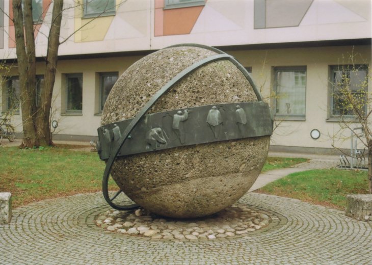

![]() Das Denkmal für
Johann Georg von
Soldner
befindet sich auf einem kleinen Platz unmittelbar an der Kreuzung von Oettingen- und
Liebigstraße im Münchner Ortsteil Lehel. Es ist in Gestalt eines Globus'
gestaltet mit einigen Bezügen zur Geodäsie.
So zeigt das Band, das den Äquator realisiert, symbolisch typische
Tätigkeiten bei Vermessungsarbeiten. Ferner enthält es auch eine Inschrift in
lateinischer Sprache - aber auch gleich mit Übersetzung ins Deutsche:
Das Denkmal für
Johann Georg von
Soldner
befindet sich auf einem kleinen Platz unmittelbar an der Kreuzung von Oettingen- und
Liebigstraße im Münchner Ortsteil Lehel. Es ist in Gestalt eines Globus'
gestaltet mit einigen Bezügen zur Geodäsie.
So zeigt das Band, das den Äquator realisiert, symbolisch typische
Tätigkeiten bei Vermessungsarbeiten. Ferner enthält es auch eine Inschrift in
lateinischer Sprache - aber auch gleich mit Übersetzung ins Deutsche:
Ferner umlaufen diesen Globus zwei schmale Metallreifen, der eine einen Meridian symbolisierend allerdings nur zur Hälfte. Der andere liegt nur am Schnittpunkt mit dem Meridian an. Da sich beide Reifen rechtwinklig schneiden, liegt die Interpretation als Achsen eines Soldner-Koordinatensystems nahe. Diese lokalen Koordinatensysteme wurden für beschränkte Gebiete der Erdoberfläche (als Oberfläche eines Rotationsellipsoids) verwendet. So ist zum Beispiel die Spitze des nördlichen Turms der Münchner Frauenkirche (umgangssprachliche Bezeichnung) der Koordinatenursprung des Bayerischen Soldner-Koordinatensystems. Die Soldner-Koordinatensysteme wurden dann im 20. Jahrhundert durch die Gauß-Krüger-Koordinatensysteme abgelöst. Die signifikanten Unterschiede sind die, dass sich Letztere nicht auf einen willkürlichen Festpunkt beziehen, sondern auf einen definierten Zentralmeridian, und außerdem die Abbildung vom Erdellipsoid in die Ebene winkeltreu erfolgt. (Anmerkung: UTM-Koordinatensysteme besitzen diese gleichen Eigenschaften wie die Gauß-Krüger-Koordinatensysteme.)
Das Foto wurde im März 2008 aufgenommen.
![]() The monument for
Johann Georg von
Soldner is located on a small place near the junction of the two streets
Oettingenstraße and Liebigstraße in Munich (urban district Lehel). The monument
is shaped in form of a globe and possesses some symbolic relations to geodesy. A metal ring
symbolizing the equator shows typical tasks of surveyors. Moreover it contains an
inscription in Latin together with its translation to German. Both sounds like:
The monument for
Johann Georg von
Soldner is located on a small place near the junction of the two streets
Oettingenstraße and Liebigstraße in Munich (urban district Lehel). The monument
is shaped in form of a globe and possesses some symbolic relations to geodesy. A metal ring
symbolizing the equator shows typical tasks of surveyors. Moreover it contains an
inscription in Latin together with its translation to German. Both sounds like:
There are two thinner rings too, one symbolizing half a meridian. The other meets the first one orthogonally which suggests the interpretation as the axes of a Soldner coordinate system. These local coordinate systems have been used for restricted areas of the Earth's surface (approximately a rotary ellipsoid). For example the northern tower of the church Frauenkirche states the origin of the Bavarian Soldner coordinate system. During the 20th century these local coordinate systems have been superseded by the so-called Gauß-Krüger coordinate systems. The most significant differences are that the Gauß-Krüger coordinate systems are not related to an arbitrarily chosen point but to a meridian. Moreover the projections are conformal which means that angles are not distorted. (Remark: The UTM coordinate systems possess the mentioned properties as well.)
Hint: Also for English speaking people it is recommended to read the German Wikipedia page too (cf. the link in the German text above) because it contains much more information on the life and career of J. G. v. Soldner.
The photograph was taken in March 2008.
| Back to the main page | Created by Wolfgang Volk in June 2008 Last formal addition on June 9th, 2009 |